 Me first aligning the rise tool, then checking
whether the slope is increasing or decreasing.
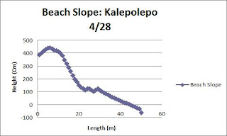
Introduction: At the beach we will be studying and measuring in the field study, the slope of the dunes of sand laying around beaches or so. Checking for the slope of each dune from the beginning toward the foot of the beach to best guess the volume. Studying the amount before swells, storms or strong current can cause further erosion of the sand at the beaches.
A team photo measuring the slope downward toward
the beach.
 Procedure
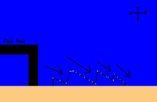
2. Set transect line.
3. Transect line ending at the water of the beach
4. Align with the compass "Red Fred facing the Shed" for the direction of the transect line
5. Take the GPS to mark coordinates.
6.
Take the run tool set on the start mark of the transect line.
7. Align right using the measurement of both rise & run tools.
8. Use
rise tool in order to set it one meter apart from the run tool parallel with the transect line.
9. Align straightly using the align measurement attachment at a 90 degree angle
10. Record data on the measurement
11. Take run tool to replace spot occupied by
the rise tool
12. Repeat steps 8 - 10 until all data is recorded
(Beach Slope Data)
(Beach Profile)
No comments:
Post a Comment